Note: This website was automatically translated, so some terms or nuances may not be completely accurate.
Dentsu Inc., Zenrin DataCom, and Rescue Now jointly developed the "Crisis Information Navigator" service for local governments, with service launch scheduled for this fall.
Dentsu Inc., Zenrin DataCom, and Rescue Now have jointly developed "Crisis Information Navi," a service for local governments that centralizes and provides emergency and disaster information for residents in a one-stop format. The service will launch this fall.
This service integrates and maps regional emergency and disaster occurrence information, evacuation centers, and other details onto digital maps. Simultaneously, it represents the industry's first solution to comprehensively address the operational challenges local governments face in disseminating information.
Currently, many local governments are working to enhance their disaster prevention and mitigation capabilities by strengthening their ability to provide information such as rainfall and river level observation data, damage status, evacuation orders, and shelter openings. However, it is also true that they face diverse challenges, including the costs, labor, and staffing required for this operation. Furthermore, local residents, as information users, experience inconvenience and lack of overview due to delayed information, differences in content between municipalities, and the limited availability of non-municipal information (such as from transportation or utility providers) often presented only as links. Considering the nature of disasters, which frequently impact multiple municipalities, an integrated response platform is essential.
"Crisis Information Navi" is a service that aggregates and provides diverse information at the municipal level. This includes the "National Evacuation Shelter Database" developed by Dentsu Inc. and Zenrin DataCom, the "Crisis Management Information Distribution Service" provided by Rescue Now's Crisis Management Information Center (operated 24/7 with staff), and AED installation information provided by Zenrin DataCom.
Beyond traditional text-based information delivery, it uniquely maps this emergency and disaster information onto Zenrin DataCom's digital maps. This enables the comprehensive, rapid, and precise provision of essential information to local residents. Furthermore, it offers a new solution encompassing everything from tool provision to operational support. This includes a menu where Rescue Now's Crisis Management Information Center provides 24-hour support for local governments' information dissemination tasks themselves.
Within this service, Dentsu Inc. handles planning and specification development, Rescue Now manages disaster information collection and acts as an intermediary for local government information dissemination, while Zenrin DataCom oversees operations, distribution, and serves as the sales contact.
The categories of information distributed via "Crisis Information Navi"* are as follows.
・Weather Disaster Information
Weather forecasts, special warnings/weather warnings/weather advisories, Tokai earthquake-related information, earthquake information, volcanic information, tsunami information, general weather information, landslide hazard warnings, river flood information, record-breaking short-duration heavy rain information, tornado watch information, typhoon information
・Transportation Information
・Public Safety Information
Health and safety information, photochemical smog information, novel influenza information, product safety (recalls, etc.) information, crime prevention information
・Emergency Information
Emergency Information, Evacuation Information, Lifeline Information, Security Information, Communication/System Failure Information, Fire Information
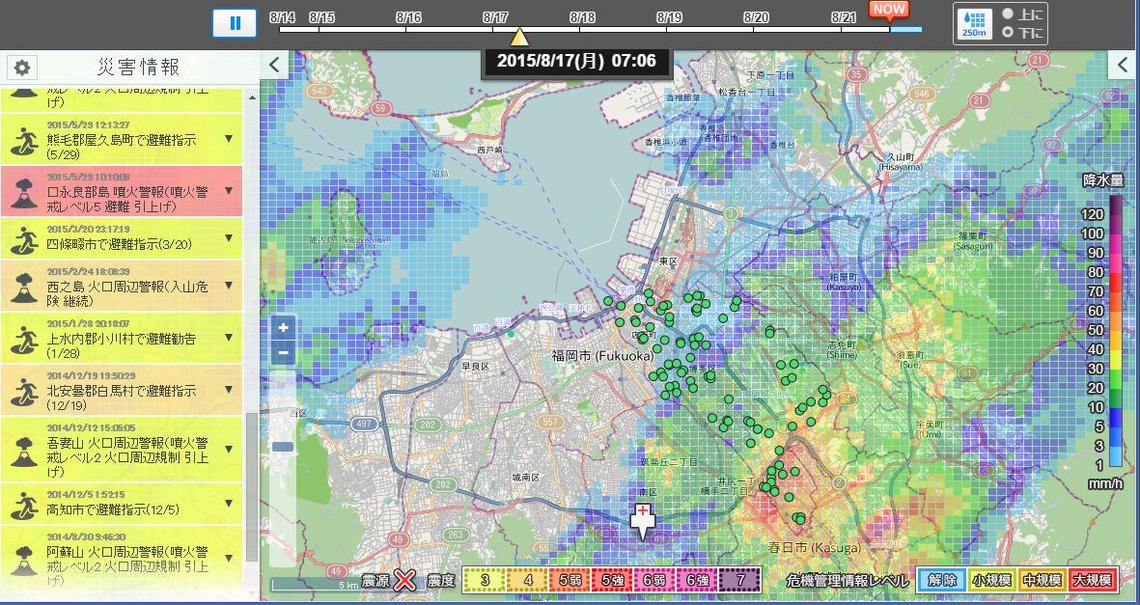
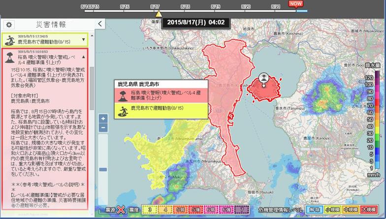
Crisis Information Navigator Image
① Combination of the National Disaster Information Panel (left side), Fukuoka City's rain cloud radar, and national evacuation shelter data (green circles)
②Sakurajima eruption warning on the National Disaster Information Panel, Kagoshima City's alert level display around Sakurajima, combined with the rain cloud radar
Dentsu Inc. News Releasehttp://www.dentsu.co.jp/news/release/2015/0901-004137.html
Was this article helpful?
Share this article